30th of January of 2014
We have done the third day:
The Basis of the European expansion
The third day the teacher explained how had done the discovery of Americas, and what kind of way the explorers used to do that.
Like I have said, the explorers and after conquerors used two kind of knowledge to discover and conquest America, geographical knowledge and new inventions, like astrolabe and magnetic compass
-Geographical knowledge:
The sphericity of Earth is a kind of thing that nowadays we known, but at 15th century people didn't know that, but we can say, since Ancient Greece, some people think that.
But from 3rd AC to 15th AC the information dissapeard, so since the first step until the second spent 12 centuries.
At those centuries, two scientist, Eratosthenes and Ptolemy made two maps:
-The first map belonged to Eratosthenes, and this map didn't have really dimensions and only appear the lands Greek knew.
-The second map belonged to Ptolemy, and in this map only appear Europe, Asia and Africa.
At the Middle Age, in Europeans' minds was a mythical geographies lands, and in the medieval maps appear for instance: Antillia island, Sete Cidate islands, Atlantis, Brasilia(another island) and San Brandan or Borondon where was the gate to the paradise.
But at the Middle Age, some travelers arrived to America, more or less at 9th century, the island of Iceland was discovered and colonished by Irish monks. After that the Vikings created two stablishement in Greenland and it is probable, the same people discovered, Newfoundland or Labrador.
At the beginning of the 13th century the merchants from Italia, Portugal and Castille went to Africa to take ibory or some spieces, and Portuguese Crown and people, who finished the "Reconquest" went to Africa and put in the coast some stablishement; from 13th century to 15th century the Castilian people, not the Crown, conquest the Canary Islands.
-Advances in technology:
Besides maps or geographical knowledges, were some advances in tecnology which get the navigation and conquest of America, but two inventions were the most important: Astrolabe and Magnetic Compass:
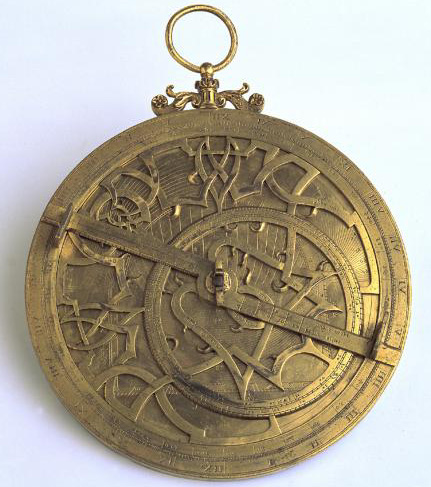
-Astrolabe: It permited to know where you are in the globe
-Magnetic Compass: Was invented by the Chineese, but European people used to discovered America.
And although the chineese technology was better, they used to go to another lands or sites.
Besides these inventions, were more, for instance: lateen sail and Sken post.
Astrolabe
The last ship, astrolabe, compass and very good maps were used by Christopher Columbus to went to the West Coast of The Atlantic Ocean, in his opinion to Catay and Cipango, but he discovered a new land:
"AMERICA"
At those centuries, two scientist, Eratosthenes and Ptolemy made two maps:
-The first map belonged to Eratosthenes, and this map didn't have really dimensions and only appear the lands Greek knew.
-The second map belonged to Ptolemy, and in this map only appear Europe, Asia and Africa.
At the Middle Age, in Europeans' minds was a mythical geographies lands, and in the medieval maps appear for instance: Antillia island, Sete Cidate islands, Atlantis, Brasilia(another island) and San Brandan or Borondon where was the gate to the paradise.
Antillia island,a map done by
Bartolomeo Pareto, 1455
San Borondon or Brandon island
map, 1707.
But at the Middle Age, some travelers arrived to America, more or less at 9th century, the island of Iceland was discovered and colonished by Irish monks. After that the Vikings created two stablishement in Greenland and it is probable, the same people discovered, Newfoundland or Labrador.
At the beginning of the 13th century the merchants from Italia, Portugal and Castille went to Africa to take ibory or some spieces, and Portuguese Crown and people, who finished the "Reconquest" went to Africa and put in the coast some stablishement; from 13th century to 15th century the Castilian people, not the Crown, conquest the Canary Islands.
-Advances in technology:
Besides maps or geographical knowledges, were some advances in tecnology which get the navigation and conquest of America, but two inventions were the most important: Astrolabe and Magnetic Compass:
-Astrolabe: It permited to know where you are in the globe
-Magnetic Compass: Was invented by the Chineese, but European people used to discovered America.
And although the chineese technology was better, they used to go to another lands or sites.
Besides these inventions, were more, for instance: lateen sail and Sken post.
Astrolabe
Compass
These inventions used in the 14th century and 15th century ships and appear new ships: Nao, Galera and Caravel.The last ship, astrolabe, compass and very good maps were used by Christopher Columbus to went to the West Coast of The Atlantic Ocean, in his opinion to Catay and Cipango, but he discovered a new land:
"AMERICA"


No comments:
Post a Comment